WEEK 9 THE SEMINAR


11140241_10204363794609792_4567053171373047521_n


THE BIG DAY !

We asked everyone to arrived at B09.2 at 2pm so start preparing for our seminar, and that the whole crew should be wearing black.

Everyone arrived on time and we divided into groups to start it up. Me, Kai, Tan and William were in charged of the techs so we 4 went down to the techs office to grab everything we needed for our seminar, and pushed the trolly to B80. We got there at 2:45 and started to unpack everything and set up. Firstly I checked all the audio equipments, and after a while we decided to stick with the room’s mics, not the wireless ones. Then we managed to get the IT guys to turn on the recording system so that we have a back up of the audio of the day.I consulted Mark for the mics , then double checked with the IT guy who came down to help. I suggested him to adjust the gain level a bit, so that everyone at the back can hear our guests since its a big room.

Next, I helped William to set up tripods and cameras , pick a spot and stable the angle. Next, I group with Dom and Henry to figure out how to be able to play our promo vids and also letting the background vid we did stays behind our guests during the whole seminar.

Then I helped out Gina with the food and ran up to level 7 to do the popcorns and brought it down in time to start the seminar. During the seminar, I filmed some of the audience’s reactions so that we have a nice highlight reel afterwards.

As an usher I also collected question sheets and feedback from everyone in the room. Finally I set up the camera and arrange our group photoshoot.

In my opinion, the seminar was amazing, despite some of the time consuming issue. Our panel was great, funny, exciting, informative and useful to every of our audiences. I’m super happy with what we did that day.

12004773_10204363749568666_9221393999694276280_n

Week 7

We had a group meeting at Building 9 level at 1:30 and the poster group was also there to present our process with others. We arranged a date to shoot Jim, listed what we need to prepare for it and who’ll be there to help out on the day. We decided to hire a EX3 Camera along with a tripod to be our props for Jim to pose next to.

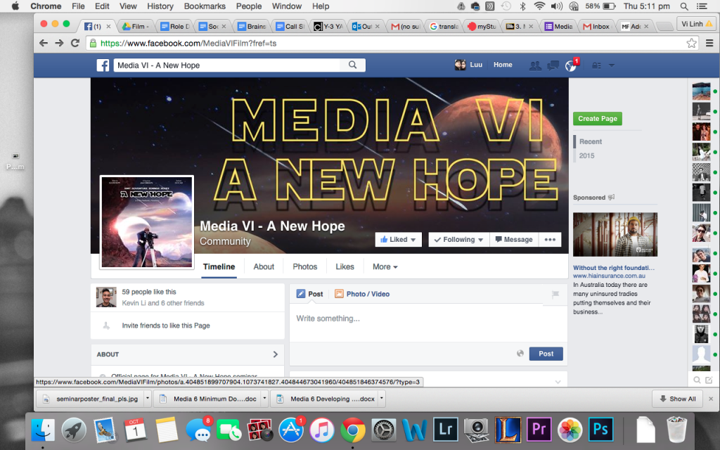
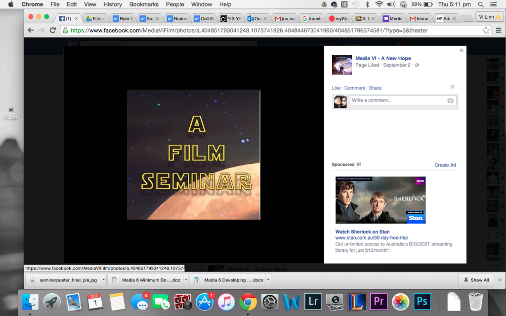
Besides the logo talk, we needed to help Natalie out with the facebook page and event.So I took the role to quickly make a profile picture and cover photo because by that time we didnt have a poster yet. So at first the group agreed that we just need a simple banner and profile pic first and wait for the poster to be done. In order to make everything looks consistant, I took the background of the poster we were doing, as the background for our cover and profile photos. Then added text on it.

Then I came up with an idea of making a profile photo that links with the cover photo on facbeook. so that it looks smartly done, not just something quick and simple. So it took me 15 mins to finish the task. Unfortunately now we changed our profile pic to antoher photo that I dont have a screenshot of my work, but hopefully you can see the point.

Screen Shot 2015-10-01 at 5.11.48 pm Screen Shot 2015-10-01 at 5.11.53 pm


Alongside making photos, I also put in ideas about food and drink at the semniar, and offered to help the tech crew in setting up cameras, mics and lighting.

Week 5

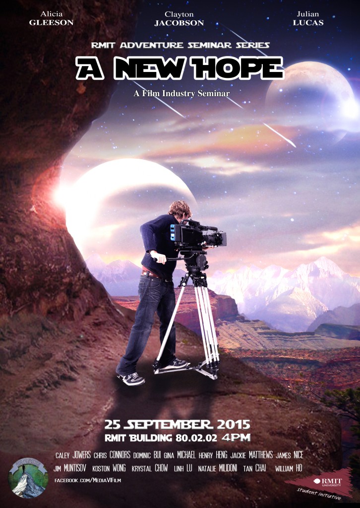
In week 5, our group decided to assign roles and I got poster making , along with Henry.  By that time there was’t much information available for us to brainstorm ideas but we looked up Star Wars sample logos and themes, dowloaded fonts and arrange texts composition as a draft first.
After a few weeks, we have finalised our idea into putting Jim , our host as our main character, standing next to a camera and a tripod, in a Star War inspired background with Star War texts.
First it was quite easy and straight forward to come up with it. But the actual designing process took more time that we expected. First it was hard to layer all different planets landscapes into one photo without making the whole thing looks fake. Henry did the layering work first, then I corrected the brightness / contrast , fix the texts and colors. Then to be able to deliver our ideas to the group, Henry took a shot of himself holding a camera, as a draft version of Jim’s to show everyone. And by doing that, we knew what we need to do at the actual shooting day, how Jim should pose, what should he wear, etc. By the end of week 6, we got the shots of Jim, but putting him in the poster was still a complex task, since we need to balance the lighting and color.
* Work still in processseminarposter_final_pls

Brief 2

Name : Linh Luu

S3387253

BRIEF 2


In this task we sort to find out what is wayfinding and how it works in a variety of contexts. We are looking at ways in which place is represented through different APPS relating to maping and wayfinding.

Specifically, we have narrowed down to 3 certain apps : Lost on Campus, RMIT Map ( belongs to Lost on Campus ) , and RMIT Map2  ( developed by Yichi Zhang ).


Together we looked at over fifty references, explaining why a platform such as mobile’s apps is playing such important role in wayfinding, especially in this extremely developed and depended on technology society. We also researched closely at the process of app making in two different platforms which are ISO and Androids, the software that they use, the expectations and needs of users when downloading a wayfinding app and the geographic information system.
I personally had an interview with the RMIT Map app ( developed by Yichi Zhang ) team, including the 2 supervisors and the developer.

The first reference we looked at was 1Cresswell, Tim (2015) Place – An Introduction, Wiley, UK, in this book Cresswell stated “fusion of mapping software with social media software” (page 3 ) that not only provides information about a certain place, but also the linking of data between people, places and things.  The remarkable rise of mapping software with social media software – mostly mobile applications, as Cresswell mentioned, has enabled new level of augmented place. This has lead us to look at how apps nowadays affect people lives, especially wayfiding apps. We examined RMIT Map app and not only it shows users RMIT campus map but also updates users current location and automatically shows it on the map, then directing users to selected location (buildings, landmarks,etc ). And that represents the merging of Geographic information system (GIS ) and social media apps , which is also the second reference, to understand more about GIS and how it affects the mapping system.


“A Geographic Information System or GIS is a computer system that allows you to map, model, query, and analyze large quantities of data within a single database according to their location.” –  2How We Use Data in the Mid-Atlantic Region | US EPA. 2015The article explains clearly what is GIS and how does it work and how it has become so big in our society. GIS can show many different kinds of data on one map. This enables people to more easily see, analyze, and understand patterns and relationships. Also, in 3GIS (geographic information system) – National Geographic Education. 2015. GIS (geographic information system) – National Geographic Education. [ONLINE] Available at:http://education.nationalgeographic.com.au/education/encyclopedia/geographic-information-system-gis/?ar_a=1. [Accessed 26 March 2015], states that GIS can use any information that includes location. The location can be expressed in many different ways, such as latitude and longitude, address, or ZIP code. The system can include data about people, such as population, income, or education level. The interactive maps you view on a phone or the Internet use GIS technology. Using Google Maps, people can add traffic information to road maps or view satellite images of their town or neighborhood. And that’s how the map apps function as well, as GIS plays a crucial role in processing the apps.


We also wanted to understand more about Wayfinding, and as in 4 “RMIT Central Authentication Service. 2015. RMIT Central Authentication Service. [ONLINE] Available at:https://equella.rmit.edu.au/rmit/file/d8ceb3ec-487d-49b8-b88f-5e766d2489a3/1/150219_3_023.pdf. [Accessed 26 March 2015].” , defines it as the process of using spatial and environment information to navigate to a destination. Wayfinding involves 4 stages: Orientation, which refers to determining one’s location relative to nearby objects and the destination ; Route decision refers to choosing a route to get to  the destination ; Route monitoring refers to monitoring the chosen route to confirm that it is leading the destination; Destination Recognition refers recognizing the destination. These 4 stages apply exactly to the process of MAP’s applications on different platforms.


“Make your app work with others. Full integration with the host platform helps users feel at home with any application and lets applications interact and exchange data”, said Esposito–  5 Esposito, D. (2012). Metro app design principles. InformationWeek, (1338), 34-35. Retrieved from http://search.proquest.com/docview/1038004707?accountid=13552.  So not only just showing only a campus map, these apps let users exchange info and data with other users, setting their favorites routes and places, such as coffee shops, dropping pin at smoking area, etc. “the heritage trail, sustainability trail provide information about the buildings which may be of interest to people.  Other information people might want would be coffee shops and bike parking.  We thought about academic information, but decided that would be too specialised and might make the app slower, and people could perhaps build that themselves as their favourites”, said Dr. Maria Spichkova, Computer Science & Info Tech, RMIT, RMIT Mapp app supervisor

After interviewing Margaret Hamilton- Associate Professor,

School of Computer Science and Information Technology 

RMIT, one of the supervisors of the RMIT Map app, we got to know the process of making the app and almost everything about the project. 6“It was a summer project, presented by Margaret Hamilton and Maria Spichkova – we had thought of it during a workshop on sustainability and public transport held at RMIT with Linda Stevenson who also had lots of ideas about what should be in the maps. “

Futhermore,  there are different groups in an app design project, which are Core group, Advisory group, and 2 Co-desgin group events 7(Sangiorgi, Daniela, and Meroni, Anna. Design for Services. Farnham, Surrey, GBR: Ashgate Publishing Ltd, 2011. ProQuest ebrary. Web. 26 March 2015) .

Additionally, mobile platform development has lately become a technological war zone with extremely dynamic and fluid movement, especially in the smart phone and tablet market space. Through 8 Sumi Helal, 2012. Mobile Platforms and Development Environments (Synthesis Lectures on Mobile and Pervasive Computing). Edition. Morgan & Claypool Publishers, we came to understand more about the three currently dominant native platforms – iOS, Android and Windows Phone and the basic process of making the apps. For example, the Android operating system produced by Google has over 70,000 apps available, while the iOS 4 system used by the Apple iPhone has over 200,000. 9(Poyntz, N. (2010). Tapping in to the past. History Today, 60(10), 29. Retrieved from http://search.proquest.com/docview/760963539?accountid=13552

http://search.proquest.com/docview/760963539?accountid=13552

).  And according to Yichi Zhang, the developer of RMIT Map app, “Those who won scholarships were given the list, and the 3 of us selected it, and decided it would be for iPhone.  We approached Linda Stevenson to fund a separate scholarship for the Android version. Once the maps and building coordinates were sorted out, we worked in two separate projects really – android and IOS are so different and complicated.“

In conclusion,

Reference List :


  • Cresswell, Tim (2015) Place – An Introduction, Wiley, UK, in this book Cresswell stated “fusion of mapping software with social media software” (page 3 )


  • How We Use Data in the Mid-Atlantic Region | US EPA. 2015.


  • Dr. Maria Spichkova, School of Computer Science and Information Technology, RMIT, RMIT Map app supervisor.


  • Margaret Hamilton- Associate Professor,School of Computer Science and Information Technology,RMIT,RMIT Map app supervisor


  • Sangiorgi, Daniela, and Meroni, Anna. Design for Services. Farnham, Surrey, GBR: Ashgate Publishing Ltd, 2011. ProQuest ebrary. Web. 26 March 2015) .


  • Sumi Helal, 2012. Mobile Platforms and Development Environments (Synthesis Lectures on Mobile and Pervasive Computing). Edition. Morgan & Claypool Publishers,


  • Yichi Zhang, Developer of RMIT Map App ,Student Service – Study & Learning Centre , RMIT.
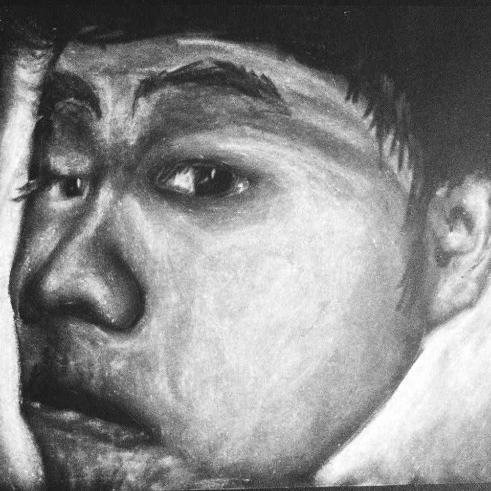
Editing

So I spent 3 days at the Suites to try to finish my video.The first 2 days were fine, I finished editing all the scenes in order and time, inserted music and transitions smoothly . But the 3rd day at the suites didnt go well, as I had trouble with the audio files. Editing the project using 2 different computers caused the problem, as the software I was using were 2 different versions so it couldn’t recognise the files.
So I had to switch to plan B, inserting subtitles instead of using a narration. Because there weren’t much time left so I rushed this process and the final piece came out not as good as I expected and Im not happy with it…..

LESSON LEARNED.

Filming

So I decided to film my piece with a 5D Mark 2, 18-75mm lens, and a tripod.
After contacting Marc Morel , I came up with a confirmed filming date and had no problem with entering the building.

I started to film the outside of Storey Hall first, by placing the tripod just in fonrt of the 7 Eleven store opposite building 16 , and recorded a close up shot for about 15 seconds of Storey Hall’s titles and widow and entrance, then a 2 minute time-lapse with wider angle, capturing the whole area : people walking around ( in the rain ) , trams and cars and pedestrians passing by.

Then filming inside was fairly easy and straight forward,as I always complete all the wide shots needed first, then focused on the details of the architecture, such as ceilings, lightings, shapes, colours,stairs and walls.

Overall , filming day was a success, only took 3 hours.

Final Reflection

1000 words reflection :

Cresswell begins to explain the concept of space, stating that space is viewed as an area without meaning, as something basic and unrelated. However, he then says that once a human invests meaning into a space, they then become attached to it in some way, thus, it then becomes a place.I am interested in the ways in which place plays an active role in the constitution of culture and society.So this inspired and triggered me into making “The Residue” , exploring the facts and meanings behind the architectures of Storey Hall.

Cresswell stated ‘the ability of place to make the past come to life in the present and thus contribute to the production and reproduction of social memory.’ This truly indicates to my individual project , as I would never understand Storey Hall’s use of different colours, or the brick wall, the geometric shapes if I don’t realise it’s connection with the place’s memories. It is a building of endeavour and industry, celebrating individual qualities of making things, materials , textures, casting metals, colouring walls, and the power of imagination which adapts new communication and transmission technology . Storey Hall seems in the end to argue the glory of the human mind over that of artificial logic. Making people to wonder and start searching for it’s former lives, instead of visually show it on signs.

So from Cresswell’s idea of place is represented by it’s former lives, and the art of noticing in place and space, I have decided to focus on Storey Hall’s designs, as from my first time visiting the building, I was amazed and impressed by Its architecture aspects and how they instantly bring visitor an unique mood of playfulness and complexity. So I started to investigate and notice more, the use of lights and colours, the actually-not-random shapes and last but not least, the brick wall. As I noticed that Geogre also came across the brick wall and started to wonder the same question, what’s the purpose of leaving a brick wall surrounded by modern concrete walls, and that must be related to the building’s history, a hint from the architects to the public, that we should research deeper and find out by ourselves.

The brick wall brought me into researching a lot about Storey Hall’s histories and the architect’s message through the odd designs. And with the help of Abigail, I found an interesting interview on BBC, where the architects at A.R.M talk about their works. That’s when I decided to make a short documentary about Storey Hall’s architecture facts in relation to it’s former lives, using shots of it’s very special designs and follow up with a narration. Later on, Rachel introduced us a book called “Mongrel Rapture” , written by the A.R.M architects. That book has fulfilled my need of sources and information, helping me to finish my script and an informative and detailed narration.

There has been some difficulties and problems during the process of making my video. Firstly, I was flooded with too many information and facts about Storey Hall’s architecture design that I went off track in my narration and storyline. So after sorting out all the crucial information needed, I rearranged the narration to a simple but informative enough one, in order to still make the documentary not too long and boring. Secondly, the whole project to me was very time consuming because it’s an individual assessment. Previously , Im used to working in a crew where I never have to worry about writing a good plot, arranging work loads , preparing and casting narrator. Now I have to be a director, a producer, a cameraman and a post-production man in the same time. So I struggled without knowing it. I spent too much time on the wording process that I lacked the time to film,edit and narrate. So I rushed the editing process, causing a serious trouble with the audio files. I didnt convert the files ,and because I used 2 different computers at the same time, the files corrupted and I had to switch plans, using subtitles instead of a narration, which is far less effective, lack of creativity and is really boring and plain , but I had no choice. I think visually it’s not bad, but overall, my piece does not reflect me and my ability at my best. And honestly I’m not happy and satisfied with my final outcome.

On the other hand,I enjoyed the challenge of working solo and the experiences it brought me, so that I can learn from my mistakes and improve in the future. Also, I love participating in our group work where I can offer my abilities and experience to others, help my classmates to complete the virtual tour works and also their individual piece. I enjoy executing the idea of using youvisit and witnessing how the virtual tour turned out visually. About improvements, I could have arranged my time smarter, not rushing any process and execute my video better than this one.

I have discovered about my own creative practice that I tend to focus more on the wording process this time than the filming and executing the piece , which is completely different from previous semesters. That Im interested in hidden meanings and secret plays of telling stories through architectures. That I worried about completing the task too much that I lacked the use of creativity which I never failed at before. An interesting discovery after this semester.

Through out the course, my understand of place has developed from just a space, as I have not invested meaning in it yet, therefore, it cannot be transformed into a place; something solid and concrete. Although the media representations have provided me with a ‘sense of place’, it is not my own constructed meaning, hence it is not constructed personally; I merely take what the films show and regurgitate those mediated meanings. However, once I have noticed, and experienced, and researched about it, the idea of “space” transformed and involved into a certain “place”, with its histories, its own beauty and meanings rather than viewing it just as a physically location.

I have learned to notice more about memory, space, place and I also learned the importance of researching materials. From googling a phase to a really deep and informative search online and at the State Library, from just brainstorming ideas into backing it up with facts, histories, statistics and references. Moreover, I learned and experienced more about group work and how important communication and chemistry is .I believed I have acquired a lot of knowledge, skills and experience from this course.


Readings

Site Visits

Guests

Briefs

Work in-progress


Jeremy Bowtell

I did not attend class while Jeremy talks about editing because I was too busy merging the panorama photos for the group work, but I got to meet and talk to him while the class was at the editing suites.
I have experience in editing from my part-time job as a photographer and filmmaker , but still I needed to know some of the technique I want to achieve for my video, and I thank Jeremy for easily explained and showed me what I needed.

3 things I learned:
Use of Frame Hold ; Use of Paste Attribute and Conform frame rates.

These 3 things I learned had helped my video a lot, visually.

Abigail Belfrage

Back to the week when Abigail Belfrage came to class and helped us individually with researching for our own project.
She had helped me with digging deeper at Storey Hall history in order to collide with its nowadays architect aspects, exploring the history of the Woman’s Association , the Australian – Irish politics and the refurbishment process in 1995.

Also I learned a few search tips from Abigail :
Use different terms ( synonyms ) to search to achieve more results

And I found an useful interview of the A.R.M Architects with the BBC, where the Minister of Planning, RMIT Chancellors and the architects talked about the refubirshment process, from the very first day when they introduced the drawings, to the day it’s finished.

Melbourne Museum

What ARTEFACTS indicate particular notions of ‘place’?
Things that were of significance that indicate notions of place to me are the WWI Exhibition and Little Lon.
The dinosaurs , the mamals and the media section were really amazing as well. I spent 20 minutes at the Media place, with all the projected films and student’s projects.

What elements on display are distinctly MELBOURNE?
I came across the Melbourne transports , Melbourne’s streets, the Capital Theater , the West Gate Bridge and Luna Parks. I find these elements really interesting , as I spent 7 years here in Melbourne and those elements truly make Melbourne Melbourne to me now. As if my friends or parents would come and visit Melbourne, I’d show them the same things.

What have you noticed about the WAYFINDING techniques used throughout the exhibition?

There’s a map with titles, detailed descriptions and signs almost every corner of the museum. I started with visiting the insects, animals seciton first, then headed to the human’s history and further. So I guess the structure is guided through a timeline ?

Does the exhibition take care to tell ‘multiple’ stories… what are these?

The stories of the white settlement and the aboriginal histories were separated into different areas but kinda linked together somehow.


How does the Museum deal with ‘difficult’ or ‘tragic’ stories?

They didn’t emphasis embellishments, just stating facts and standing on a neutral , simple point of view.

What “media” do they use to tell the stories?

As mostly other museums use :Displays, viewing objects with descriptions; Soundscape; Digital Map, Projected Short Films/Documentary; Interactive Objects.